

Project partner University of Plymouth researchers are examining the extent to which human development has taken over what used to be active dune areas (i.e., areas of the dune that are dynamic and change according to wind and wave conditions). They use 19th century historical maps, World War II aerial imagery, and England’s national coastal aerial photography dataset to evaluate and map changes in active dune extent across the 40 MS4S.
They have found that the vast majority of sites show a substantial decline in active dune area, while almost half of the systems that have have lost more than half their historical extent. Most changes occurred after WWII primarily due to tourism-related development. The figure below shows the active dune area extent of the Perranporth – Penhale dune system, one of the largest in Cornwall, over the three epochs: historic (left), WWII (middle) and contemporary (right). Part of the dune at its northern end was taken over by the Penhale Camp military training base before WWII, but the majority of the lost active dune area is now occupied by the Perran Sands holiday park. Work continues to establish changes in vegetation cover on key sites to establish a baseline that can be used within an ecosystem-based dune management framework.
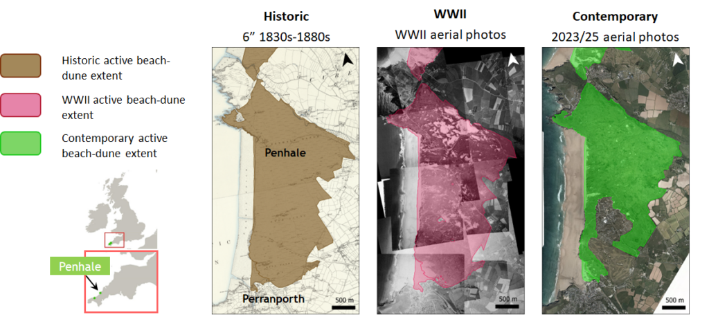
Dune extent analysis


Making Space for Sand News and Events
We like to keep supporters of our project well informed of project progress and developments. We also want to share news of events which are happening and have happened and celebrate coastal community involvement.
Sign up to Making Space for Sand
If you would like to get involved in helping to make dunes more resilient and biodiverse, want to help develop coastal adaptation and emergency plans or just want to know more about what the project is learning about coastal change, please click here: